Lessons from 3.11 #02: Google maps+satellite/aerial photos+car probe=very useful!

When 3.11 (i.e. Great East Japan Earthquake) took place three years ago, Google was very quick to respond.

A few Googlers started working on localization of Google Person Finder; it was up and running within 106 minutes after the earthquake. That was when Google has opened and announced first version of Google Crisis Response page in Japanese.
Six hours after that, the team found out, most people were still using feature phone (back in 2011) and couldn't access the web page, so they have modified Person Finder and made it accessible via Japanese feature phones.
(FYI. after Typhoon Yolanda hit Philippines in 2013, Person Finder also became accessible through SMS).


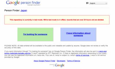
Google Person Finder will let you search (or report), if your friends/family are ok after a disaster. Click the image above to try it out in test mode.

Another group lead by Kei Kawai started to prepare satellite photos and aerial photos of the area of damage; Kei did so after the advice of Kevin Reece, who had experience in responding to a big natural disaster and who knew aerial photos will be very important.

Before I explain further, perhaps, I need to clarify the difference between Satellite photos and aerial photos. As the name implies Satellite photos are took in space (by the Satellite) while aerial photos are taken from the sky by airplanes. Because the distance between the ground is greater, satellite photos are good enough to recognize landscape and bigger architectures, but it is not as clear in detail as aerial photos.


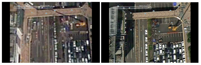
Satellite image (left) vs Aerial Photo (right)

The Google team asked Japanese government for permission but they was not as cooperative as Google expected, so it took a while until Google was able to provide the first aerial photos.

In order to prevent this kind of mishaps, I will explain why you would need it.
The aerial photos are, of course, very useful for the victims and those worried to recognize how severe the damage was.
But it is not just that.

It will be used among the rescue team to recognize how they can approach the area of severe damage (e.g. which shore, which road, which landing points, etc.).
It will also be used among those rescue team to mark which areas are searched, etc.
Aerial photos can also be used by those people who are planning to build shelters.

Satellite photos may also help. But it is best, if you have clearer aerial photos.


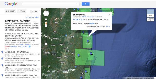
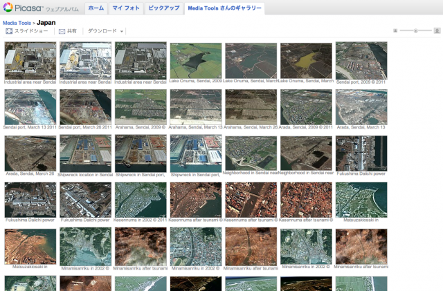
Kawai has made a custom map with links to Satellite photos shared on Picasa

After the earthquake in 2011, Kei Kawai in Mountain View was perhaps, one of the first Japanese to receive GeoEye's satellite images of Tohoku after earthquake.
By then, Google was receiving request from Japanese media for satellite images of Fukushima, but he couldn't help himself from checking the image of coastal town in Minami Soma; his wife was from there. He was so surprise to see the coastline have shifted so much but was able to recognize her wife's house was still there after the tsunami.

These images were later used used on Google Earth but Google Earth is a gigantic complex system, and it will take time to update image, and it will take further time until everyone will be able to see the image.

But Kawai, knew some people want to use the images as soon as possible. So he picked some of the best satellite images, uploaded them to his Picasa image sharing service, then created a link on his Google MyMap.
This approach was invented by some Googlers in the UK, but Kawai took over their effort.
If someone click an area on that MyMap, the web browser would display the picture shared via Picasa.

Uploading the image to Picasa had a nice side effect. People concertned about particular area was able to form community through the comment area of Picasa exchanging information or even leaving a 'thank you' note to Google.


Because it would take time to update Google Earth and Google Maps, Kawai has uploaded Satellite photos on Picasa

Although Google wanted to take aerial photos immediately after the earthquake, because the Japanese government was not as cooperative, they had to wait for two weeks until they finally were able to start taking aerial photos; those photos were shared through Google Earth and Google Maps on March 31st, and the world saw how big the damage was.

While Kei Kawai and other Googlers were working hard to get clear photos of the damaged area in Tohoku, a Japanese car manufacturer, Honda was trying to spread an important information.

Honda has an advanced telematics services for their cars called Internavi since 1998.
One of the interesting feature of Internavi is that it can share the probe information with other Internavi users; i.e. you can share information about where your car is and how fast it is moving. With this information, driver of cars equipped with Internavi will know the average speed of cars on each streets across Japan.

Back in 2004, there was a big earthquake near Niigata Prefecture (Niigata Prefecture Chuetsu Earthquake ) and Honda's Internavi team found another interesting use of car probe information; it will visualize which roads are not working.
If you have a big disaster, roads will be closed for landslides, for fallen trees, for tsunami, etc.
And those car heading to rescue the victims will waste great deal of time figuring out how they can approach the damaged area.
But Internavi team knew which roads are dead and which roads are alive because if a road is closed there will be no records of car probe on that road.
So in 2011, Internavi team of Honda has compiled a car probe data gathered from Internavi, compiled it as a KML file (a geographical data that can be overlayed on Google Earth) and shared it via Twitter.

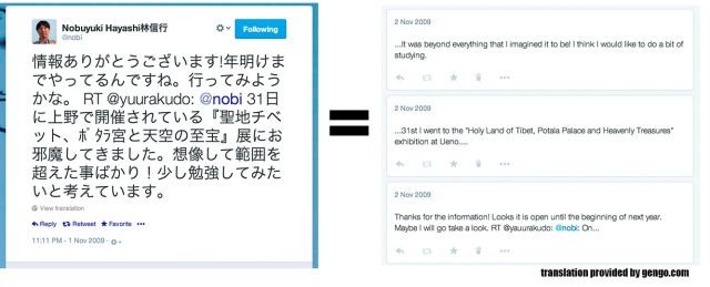
Many people tried to connect the guy from Honda to people at Google (I was among the many who tried it). Later, they found each other and started a joint effort and ultimately, it has become part of the many Google Crisis Response service unique to Japan.


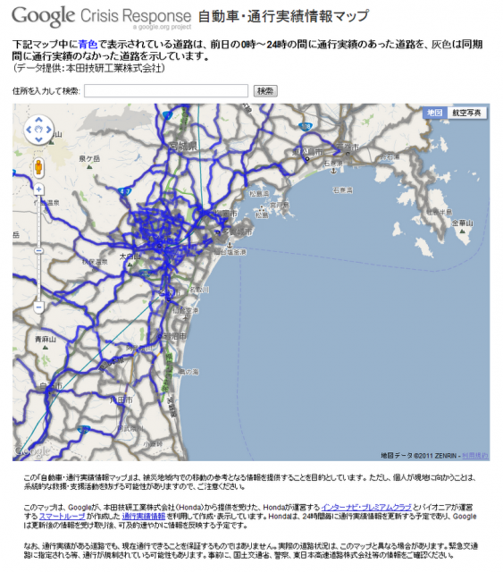
Honda Internavi car probe data mapped over Google Map (and offered as part of Google Crisis Response)

This information was so useful. One of my photographer friend check this info on his iPhone and drove all the way to Tohoku.

Kazuma Watanabe is a head of an NPO who helped so many after the earthquake; Kazuma arranged a few cars full of goods heading toward coastal area where Tsunami hit. In the mean time, he stayed in Sendai and was checking the probe information and directed which road his staffs should take through phone calls.

Let me walk through how these information can be useful in action.

Let's say, you are heading to Shiogama city through a coastal highway and check Google x Honda probe information. And then, you find people are avoiding the area around Sendai Airport and Natori river.
So I would open Google maps or Google Earth and check what's over there.
And you find the bridge over Natori river were taken down by the Tsunami and gone.


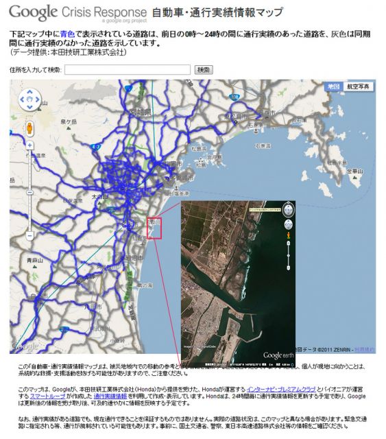
You found via probe information people are avoiding Natori River; you check the area with satellite image to find the bridge is gone


投稿者名 Nobuyuki Hayashi 林信行 投稿日時 2014年04月03日 | Permalink

Lessons from 3.11 #01: Twittersphere under Great East Japan Earthquake

A week from now on March 11, 2014, we commemorate the 3rd anniversary of Great East Japan earthquake.
I still remember how I was in the depths of despair only three years ago. Before the earthquake, Japan was anxious that GDP of China will finally surpass that of Japan; the TV news was repeating that neither Japanese population nor the GDP will be on the uptrend again.
Then, on March 11 came the earthquake.


Above is the vieo, I took. I was in Shibuya, Tokyo. Tokyo is about 375Km (or 233 Miles) away from the seismic center: about the distance between Manhattan to New Hampshire (i.e. passing over Boston) or between Paris center to Stansted airport in the north of London. It took a couple of minutes until the tremor hits Tokyo but still it had this much power. And this was only the starter. We had uncountable aftershock after the first wave, how could we not think it was the doomsday?


Above is an animation I found on YouTube that shows all the tremor that happens in 3 days between March 11th and 13th, 2011; wait until the counter hits 2011/3/11 14:46 and imagine being in Tohoku where most of the electricities and the phone lines were gone.
We could hardly imagine that Japan would play a key role in world economy again.
But most of Japan except for Tohoku has recovered since then. There is still a long way ahead for Tohoku and even longer way ahead for some areas in Fukushima.
That is all thanks to people around the world who supported Japan and I think Japanese ought to share some of the lessons we have learned in that earthquake.
After all, I believe that earthquake was one of the most digitally archived natural disaster in human history. And not only Japan, but the whole world can learn so much important lessons from it.
You may ask how digitally archived it was.
Well, first of all, there are so many YouTube video, Flickr, Picasa and mixi photos of the earthquake and tsunami because smartphones and digital cameras have large penetration all over Japan, so we had the mean to archive the real disaster.
Then, there was Twitter which perhaps became the most used IT service after the earthquake.


Twitter: the Communication Tool for Natural Disaster

Actually, Twitter had been the tool communication tool for earthquake even before the big Earthquake on 3.11. You know, in Japan, we have earthquakes more often than many other countries; even in Tokyo, we have at least three or four earthquakes that we can feel plus more than a dozen smaller ones that we don't feel; perhaps, there were less before 3.11.
In anyway, even before 3.11, whenever an earthquake happens, people using Twitter would have immediately launched Twitter App on their smartphones and check if it really was the ground that was shaking or if s/he was just feeling dizzy and tweeted "shaking!" (in Japanese.)
Many people in Japan understand the real time value of Twitter so well that they didn't type long words, so sometime, we could visually witness how the seismic wave transmits. For example, if I see a guy in Shizuoka city tweets "shaking" and then, another friend in Kamakura city tweets "shaking" 30-40 seconds later, I would feel the earthquake and tweet "shaking" about 20-30 seconds later, or something like that.
There are also many (ro)bots that would automatically tweets information about earthquakes.
Facebook and mixi weren't as efficient in spreading and gathering info of so many people in such a timely manner because they are optimized for communication within closed groups and because it would let you describe so many other things with more than 140 character that by the time, you finished writing, everybody would forget about the earthquake and moved on to the next topic.
Also, because the thing you can do with Twitter is so limited, it was so easy for newbies; many people in Japan heard, Twitter is helpful right after the earthquake, and those people started using Twitter as one of their first internet communication tools after e-mail (e-mails on feature phones had been a very popular tool for a long time even before Smartphones came along). Today, Google+ may come after Twitter for the ease of setup & ease of use; but I think Google+ is too complicated (you can do too much) for novices, especially for elderly people (people in the tech industry should understand more feature = more to learn before you can use it).

So when 3.11 happened, Twitter was the natural communication tool of choice for the many. And although the connection over major phone operators were too congested, many business people had portable Wifi connections that they could use.
They used it to share/find out what's going on around them; there had been tons of amazing conversations going on from a girl asking for help from under the collapsed brick wall to cafes in Shibuya opening up their space as temporary shelter, etc.
As one of the recommended users of Twitter chosen by Twitter, Inc., I have 200,000+ followers on my Japanese language account @nobi and I had gone thru some amazing conversations but I will pick those up sometime in a later post.

In this post, I would like to focus on some of the most important lessons, I have learned.

Tracing Back the Info

Under a catastrophe, people panic and tweet info that would only cause confusions.
For example, I saw a Tweet by a girl shouting "big Tsunami is about to hit Sendai!"
(I may be making it up a little bit because I can't find the original).

@SomeJPGirl: big Tsunami is about to hit Sendai!

That Tweet had been retweeted so many times that even though I was not following her, the tweet came into my eyes.
It was way after the Tsunami took over the Sendai airport; I was shocked to hear the Tsunami is hitting Sendai again.
I took a careful look into her Twitter account to see if she is in any danger.
Then, I realized right after that tweet, she was tweeting "I have to find a way back home (in Tokyo) from Shibuya station (also in Tokyo)."
So she was not even in Sendai. She was stuck in Shibuya station and was watching the news of Tsunami hitting Sendai on a public TV.
She has done nothing wrong and she didn't intend anything harm, but the context will become very important in such circumstances.
And because the influence of information is so big under catastrophe, IT literate people shouldn't just respond by reflexes, but rather take some moment for careful investigation before tweeting or retweeting.

Time Stamps

People were exchanging information about the aftershocks, update info by government and public services; that day in 3.11 (and for at least two weeks after that), there have been too many of those.
And every time, an aftershock hit their cities or every time an important announcement has been made, people tweeted. And many people retweeted.
Later, there were too many similar tweets that people started to get confused which is the latest info, especially Twitter would only show approximately how many minutes or how many hours ago, that tweet was made.
So many people started to suggest to put a time stamp within tweets, so people can tell which info is more recent; actually, today, you can bring your mouse over the Twitter's official time stamp and it will tell you the time and dates, that tweet was posted.


Today, if you move your cursor over the Twitter's time stamp, it will reveal the exact date/time.

Importance of Official RT

In the English and other languages using phonetic alphabets, you can express so little in 140 characters.
But in Japanese, we use a mixture of phonetic alphabets and ideographs (a character is worth a word in English or sometime, it has more than one meaning). Because of this, we can express so much in 140 characters; the laws of physics (or linguistics) are totally different in English Twitter-sphere and the Japanese Twitter - sphere.
Gengo.com, a Japanese startup that provides multi-lingual translation services, used to translate tweets of famous figures in Japan into English and vice versa. My English twitter account @nobi_en belonged to them until January 2014 and all of the tweets there prior to that date were translated by their services.
Matt Romaine of gengo.com, once told me a full 140 characters tweet in Japanese would translate into three to four English tweets.


And because of this, we often nested a few tweets in one (i.e. Embedded a few tweet-quotes within a single tweet), so we can share the conversation with many more people.
Even some English speakers are doing this today by adding "MT" (stands for Modified Tweets) before the quoted tweets.
But these modified Tweets will cause a big confusion under catastrophic situation.

First of all, it will kill the "time stamps."
Let's say you saw the tweet by the Tsunami girl in Shibuya (my prior example) and felt the urge to warn friends in Sendai.
With your habit of modifying a tweet, you might tweet:

@SomeJPBoy: Friends in Sendai, please evacuate! MT @SomeJPGirl: big Tsunami is about to hit Sendai!

By this tweet, the traceability of the tweet has moved a step further.

There was a girl under a collapsed wall whose only mean to cry out for help was the twitter app on her cell phone. Her tweet has been retweeted so many times (I've retweeted her, too).
A few hours later, I saw modified tweets about her was still circulating around.
It looked something like this:

@SomeJPBoy: if there is any rescue team near XXXX city go rescue her! MT @SomeJPGirl: Help me! I am under collapsed brick wall near XXXX, I can't move!

投稿者名 Nobuyuki Hayashi 林信行 投稿日時 2014年03月05日 | Permalink